Aquifer Tests – Timing is Key
Springfield Township posted correspondence dated January 9, 2026, from Reuben Maxbauer (Government & Real Estate Relations for Levy) regarding the planned installation of an exploratory well.
As discussions continue around the proposed sand and gravel mining operation, the term aquifer is frequently referenced. With test well installation expected soon, this is an important opportunity to clarify not just what aquifers are, but how and when they should be evaluated.
What does Aquifer Testing Actually Measure?
An aquifer performance test (sometimes called a pumping test) is designed to measure how groundwater behaves under stress.
During testing, water is pumped from a well at a controlled rate while nearby monitoring wells measure how the water level responds.
In simple terms, aquifer testing helps answer a very important question:
If water is removed from the ground, how does the groundwater system respond?
The results of an aquifer performance test help inform decisions about potential impacts, mitigation measures, and long-term monitoring.
That is why the location, timing, and design of the test matter.
Below is a brief overview of the two primary aquifer types found in the Springfield Township area, along with questions I have regarding the use of the public well database and recent correspondence I had with Supervisor Davis regarding this matter.
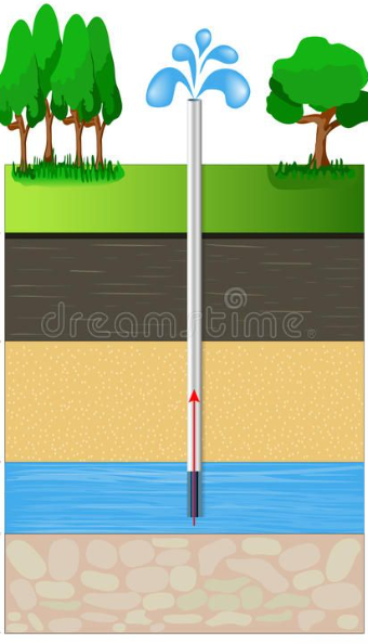
What is an Aquifer?
An aquifer is a layer of soil, sand, gravel, rock, or a combination of these materials that can store and transmit groundwater in quantities sufficient to supply wells, wetlands, streams, lakes, etc. In Springfield Township, groundwater moves slowly through porous spaces and fractures in the geologic material. This movement is typically measured in feet per day (and sometimes much slower).
When we think about what lies beneath our feet, it’s easy to imagine clean, well-defined layers, like a layered cake. Something like this might come to mind…
However what is actually happening beneath the surface is far more complex. Subsurface layers are not uniform or neatly staked. They pinch out, thicken, thin, overlap, shift, and vary across relatively short distances.
To better understand this complexity, take a look at this 3D model developed by Michigan State University using data from more than 8,000 wells across Michigan (Article: Goundwater: Out of sight, Top of Mind):

As you can see, there is no “one-size-fits-all” when it comes to aquifers. Subsurface conditions vary from place to place, sometimes quite dramatically, even within relatively short distances.
When it comes to locating and testing aquifers, as the old saying goes… Location. Location. Location. Understanding what types of aquifers are present and how they behave is foundational to evaluating any potential hydrologic (water) impacts.
It is important to locate, identify, and test both unconfined and confined aquifers in and around the proposed area.
Unconfined Aquifer
An unconfined aquifer is a layer of soil, sand, gravel, or rock (or a combination of those materials) that is fully saturated with groundwater and directly connected to the land surface. The top of an unconfined aquifer is called the water table, which rises and falls in response to:
- Rainfall
- Snowmelt
- Seasonal Recharge (think of those heavy spring showers!)
- Drought
- Pumping
- Excavation
Because there is no thick, solid layer separating it from the surface, an unconfined aquifer responds more quickly to both weather and human activities. As a result, they are more dynamic, vulnerable, and sensitive than confined aquifers.
Confined Aquifers
A confined aquifer is a layer of soil, sand, gravel, or rock that is fully saturated with groundwater, but, unlike a confined aquifer, is mostly trapped between dense layers above (and often below) it. These dense layers (often clay or till) slow the movement of water flow in and out of the aquifer.
A confined aquifer is not perfectly sealed. Water is still moving underground, and eventually finds its way to natural or human-made outlets.
So how does this relate to the proposed sand & gravel mining operation for Ormond Road?
Springfield Township ‘Updates’ posted a correspondence from Reuben of Levy regarding the upcoming installation of an exploratory well:
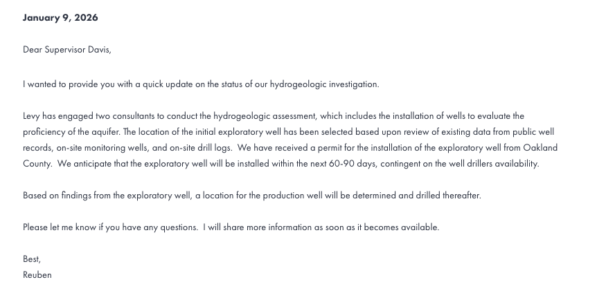
NOTE: In the correspondence, the exploratory well location is described as being “…selected based upon review of existing data from public well records…”
It is important to recognize that the public well records may not include every residential well, and some records may be incomplete, or outdated. Understanding the limitations of the dataset is an important part of evaluating how representative it is for site-specific hydrogeologic analysis.
According to the 2024 Michigan Geological Survey ‘Aggregate Mapping Grant – Committee Presentation March 2024 Status Report‘, the State reported that:
“>40% of Wellogic wells [are] not on the correct location.”
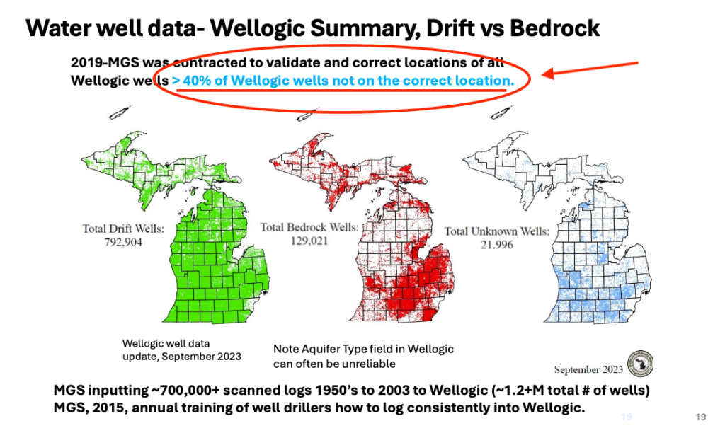
This refers specifically to mapped well locations within the Wellogic database.
In addition, there are private residential wells in the vicinity of the proposed mining area in Springfield Township that do not appear in the publicly accessible Wellogic records.
This information is important when decisions about well testing are described as being based on “existing data from public well records.”
The Township’s retained independent experts, Brian O’Mara and Mike Wilczynski, have previously requested access to relevant materials in order to provide input on where exploratory and monitoring wells should be located.
At this time, it is unclear whether independent expert has been incorporated into the final selection of the exploratory and monitoring well locations.
In an effort to better understand the proposed hydrogeologic investigation, I sent the following email to Supervisor Davis on January 24, 206, asking for clarification on several technical and procedural points.
{The following correspondence occurred while I was serving on the Township’s Fact-Finding Committee. Although I have since resigned, I continue to review the project independently, and the questions raised remain relevant.}
January 24, 2026
Hello Ric,
Thank you for posting the latest update regarding the planned hydrogeologic investigation. As a member of the Fact-Finding Committee, I wanted to do my due diligence and ask a few clarifying questions to be sure I understand both what is being proposed and how the Township plans to approach its review.
In the letter you shared, Reuben refers to evaluating the “proficiency of the aquifer”. That phrasing is not typical used in groundwater science, so I am wondering if he means productivity or capacity. In the pursuit of science, the terms used matter because they determine what is measured and how results are interpreted. This may seem like splitting hairs, but those distinctions are meaningful when discussing scientific work. For example:
- Proficiency can be read as broad, essentially whether an aquifer meets a particular need.
- Is this aquifer suited to the needs of a sand and gravel mine?
- Productivity, by contrast, refers to quantifiable characteristics.
- How much water can be pumped and what are the effects?
I also wanted to ask about timing in light of EGLE’s Aquifer Performance Test (APT) Guidance, which I have attached for reference. EGLE states that APTs for unconfined aquifers should be conducted during periods of average or below average seasonal flow and notes that this “typically eliminates the months of March, April, and May”. During this period, snow melt and spring rain can significantly affect groundwater levels and alter baseline conditions, which can influence how test results are interpreted.
Based on the 60-90 day timeline mention in the letter, installation and testing could potentially occur during that March-May window. Has the Township discussed how the proposed schedule aligns with EGLE’s guidance, particularly when the shallow glacial aquifer is involved as part of the testing?
More broadly, I wanted to clarify the role of the Township’s independent experts in this process. Will Mike Wilczynski & Brian O’Mara have an opportunity to weigh in on:
- The placement and depth of the exploratory/test well.
- The placement, number, and screened intervals of any observation or monitoring wells.
- The overall testing timeline, including seasonal considerations.
- The proposed pumping rates and duration of any aquifer performance test.
- The opportunity to observe or review testing activities as they occur, in order to support a transparent and impartial evaluation.
Finally, I wanted to ask about data access and transparency. Will the Township and its independent experts receive all raw data collected as part of the investigation? This would include baseline groundwater levels, pumping rates, drawdown and recovery data, and any field notes or anomalies. Full access to raw data is important to allow for independent review and verification of results, rather than relying solely on summarized findings.
I appreciate you taking the time to consider these questions and for continuing to share updates as information becomes available.
Sincerely,
Kara Okonewski
Supervisor Davis responded January 13, 2026:
Hello Kara,
Thank you for taking the time to review the information and for sharing your questions. I appreciate the care and attention you are giving to this and your commitment to understanding the details.
At this point, my straightforward answer is that I do not yet know how all of these items will ultimately be addressed. The exploratory well that has been referenced was requested by the Township after experts advised that a hydrogeologic evaluation could not be completed without drawing down the aquifer in order to determine what impacts, if any, the proposed mining operation might have.
Questions regarding terminology, timing, seasonal conditions, testing methods, and data collection are appropriate and important. These topics will need to be carefully examined as part of the formal review process. The points you raise are exactly the kinds of issues that should be explored when the proposal is evaluated in detail.
As we move further into the review, the role of the Township’s independent experts, including their input on well placement, testing parameters, scheduling considerations, and access to data, will be part of those discussions. Ensuring a thorough, transparent, and science based review remains a priority.
Thank you again for your diligence and for raising these questions early in the process. They will be helpful as we continue into the next phase of review.
Sincerely,
Ric