Wetlands on Ormond Road Site
Wetlands are some of the most important and often misunderstood parts of our landscape. On the proposed sand and gravel mining site along Ormond Road in Springfield Township, they are also one of the most significant environmental features. According to the submitted site plan and wetland delineation performed in 2002, the property contains dozens of mapped wetlands, including both regulated and unregulated systems.
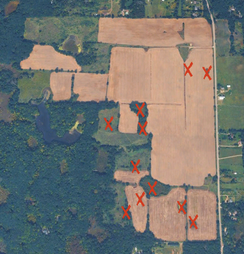
-> List of All Wetlands Identified on the Property
The proposal identifies multiple wetlands marked for removal, totaling approximately 5.51 acres (239,928 square feet)1. This map of the BMC/Levy property on Ormond Road marks the locations of the wetlands to be removed during different phases of mining.
Wetlands are not isolated features. They are part of a connected system that extends across the landscape and beneath the surface. One of the most important and least visible aspects of wetlands is their connection to groundwater. Wetlands often exist where the water table is close to the surface, relying on this shallow groundwater to sustain their soils, vegetation, and ecological function2.
Groundwater moves continuously through soil and rock below ground, forming a connected system. Because of this, changes at the surface can affect how water moves underground. Scientific research shows that groundwater continues to flow through aquifers even after land is disturbed, and that activities such as excavation can alter these subsurface flow patterns.
In sand and gravel mining, excavation removes soil and vegetation and can expose groundwater. This can change how water moves through the aquifer and, in some cases, allow water to re-enter the groundwater system and travel beyond the site3.
What Wetlands Do
Wetlands provide critical environmental functions that directly affect surrounding land, water, and communities.
Water Storage and Flood Protection
Wetlands act as natural storage systems, slowing runoff and reducing downstream flooding. During rainfall, they absorb water and release it gradually over time.
Natural Filtration
As water moves through wetland soils, sediments settle and pollutants are filtered out, improving water quality before it reaches lakes, streams, and groundwater.

Springfield Township, MI (2024)
Groundwater Recharge and Stability
Wetlands are closely tied to groundwater systems and often form where the water table is near the surface. This shallow groundwater supports wetland soils, vegetation, and overall function. Many wetland dependent species rely on these stable conditions. For example, Eastern Massasauga Rattlesnake habitat is associated with areas where the water table is near the surface and hydrology remains relatively stable.
The Eastern Massasauga Rattlesnake, a rare sight for most Michigan residents, has been declining due to fragmentation and loss of wetland habitat. The species is listed as threatened under the Endangered Species Act by the U.S. Fish and Wildlife Service4.
Habitat and Biodiversity
Wetlands support a wide range of species, from amphibians and birds to rare and sensitive wildlife, all of which depend on both surface water and groundwater conditions.
What Happens when Wetlands are Removed
The removal of wetlands is not just the loss of surface area. It disrupts an interconnected system. Removing wetlands could potentially lead to:
Loss of Water Storage
Reduced capacity to absorb rainfall can increase runoff and alter drainage patterns.
Reduced Water Quality
Without wetland filtration, sediments and pollutants can move more freely into nearby water systems.
Changes to Groundwater
Because wetlands depend on groundwater, their removal can alter subsurface water movement, potentially affecting nearby wetlands, lakes, and wells.
Habitat Loss and Fragmentation
Species that rely on wetlands lose both habitat and the connections between habitats that support their survival.
Look Beyond the First 5.5 Acres
While the initial removal of wetlands is significant, the broader mining operation is much larger. Geologic evaluations of the site estimate that between 18 and 21 million tons of sand and gravel could be extracted. Further analysis in the same report concludes that the site contains over 20 million tons of commercially viable sand and gravel reserves5. Over time, approximately 238 acres of land are expected to be excavated, reaching the groundwater. This scale of disturbance matters because:
- Mining removes vegetation and soil layers that regulate water movement
- Excavation can expose and alter groundwater systems
- Large scale disturbance increases erosion, runoff, and hydrologic instability
Research shows that mining activities can increase erosion, alter water flow, and create long term geomorphic and hydrologic changes in the landscape.
Even wetlands that remain may be affected if the groundwater system that supports them is disrupted. This means the removal of 5.5 acres of wetlands is occurring within a much larger system that is being progressively altered over time.
Why This Matters
Wetlands are not just wet areas on a map. They are active systems that store and move water, filter pollutants, support groundwater, and sustain ecosystems. At the Ormond Road site, the issue is not only the removal of 5.5 acres of wetlands, but how that removal, combined with large scale excavation, may affect the broader hydrologic system those wetlands depend on.
Understanding wetlands means understanding connections across the landscape and below the surface.
- Site Plan and Special Land Use Review – Burroughs Material Co. (2025) ↩︎
- 13.6 Impacts of Mining on Geomorphic Systems (2013) ↩︎
- Thermal Plume Transport from Sand and Gravel Pits – Potential Thermal Impacts on Cool Water Streams (2007) ↩︎
- Michigan Deptartment of Natural Resources: Eastern Massasauga Rattlesnake (n.d) ↩︎
- Hydro-Logic Associates, Inc: Geologic Evaluation of Proposed Sand and Gravel Mining Site, Burroughs Materials Co. Springfield Township, MI (2025) ↩︎