Oakland County Issues Permits for Wells on Levy’s Ormond Road Property
Oakland County FOIA records show that two onsite test-well permits were issued for the proposed Burroughs/Levy sand and gravel mining site on Ormond road.
The records show:
- ‘Test Well 1’ [#00750]
- Application/receipt date: December 3, 2025
- Permit issued: December 5, 2025
- ‘Test Well 2’ [#00753]
- Application date: December 4, 2025
- Permit issued: December 9, 2025
The property owner is listed as Edward C. Levy Company, and the applicant/contact is listed as LWD, Inc. / Lyons Well Drilling.
This appears to mark the beginning of onsite testing for the proposed mining operation.
Why are test wells important?
Groundwater is hidden below the surface, so the only way to really understand it is to study what is happening underground at the specific site. One of the first steps is often drilling test wells. These wells can be fairly shallow or several hundred feet deep, depending on the geology and what engineers are trying to learn.
The purpose of the wells is to identify underground soil and rock layers, locate water-bearing areas called aquifers, and better understand how groundwater moves through the site.
Some aquifers are called unconfined aquifers, meaning the groundwater is closer to the surface and connected to the surrounding soil and sediments. Others are confined aquifers, where groundwater is trapped under pressure beneath a denser layer underground. That difference matters because the aquifers can respond differently if the area is excavated or if large amounts of water are pumped out. (More information about aquifers HERE)
A 2025 research paper on groundwater exploration explains that test wells and borehole logs can provide useful information about underground conditions, including the types of soil and rock present, the thickness of underground layers, and the location and type of aquifers. The authors also note that test wells only provide information about the specific spots where they are drilled, so additional testing is often needed to understand the larger groundwater system1. They emphasize that effective groundwater assessment often relies on an integrated approach, combining test drilling, well logs, hydrogeologic surveys, water-level measurements, and other methods to understand aquifer properties, groundwater movement, recharge, flow direction, and vulnerability.
An article by Penn State Extension (2025) explains that once a borehole reaches a water-bearing aquifer, a screened section is installed where water enters the well2. The upper portions of the well are typically sealed with casing and grout to help prevent surface contamination from leaking into the groundwater.
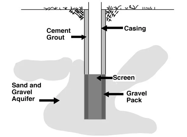
It is important to know how deep the wells are, which aquifer(s) they reach, where the screened section is located, and how the wells are sealed.
The permits issued to Levy’s contractor states that pumping capacity shall not exceed 70 gallons per minute.
This limit is important to support pump testing or aquifer drawdown testing. In a pump test, water is pumped from a well at a measured rate while water levels are monitored over time. This helps show how much water the well can produce on a sustained basis and how the surrounding aquifer responds while pumping is happening.
The Penn State Extension article explains that a well’s sustained yield depends on the aquifer’s ability to move water toward the well during pumping. By measuring water levels during and after the test, investigators can see how quickly groundwater levels drop, how far the drawdown effect may extend, and how well the aquifer recovers once pumping stops.
Of course, the value of the results depends on how carefully the test is designed and documented, including the pumping rate, test duration, monitoring locations, water-level measurements, recovery period, and whether nearby wells or sensitive features (such as wetlands, fens, etc.) are considered. At this time, none of that information appears to be publicly available.
There have been discussions that the well infrastructure will most likely become a fire hydrant or water-access point for Township use, which Township Supervisor Ric Davis negotiated as part of the mining discussions. That makes it especially important for the public to understand what is being installed, how deep the wells are, which aquifer they access, whether they are temporary or permanent, who will maintain them, and how they relate to the mining proposal.
As this process moves forward, Oko Environmental will be looking for the following information:
- completed well logs
- static water-level measurements
- pumping-test and drawdown results
- recovery data after pumping stops
- groundwater flow direction and gradient
- water-quality results, if collected
- documentation of whether the wells are temporary or permanent
- ownership and maintenance details for any Township-use fire hydrant or water-access point
This is a major step in the mining application process.
The testing methods, measurements, and results should be shared in a clear and timely way so residents and decision-makers have an opportunity to review the information, consider its implications, and ask questions. Open dialogue with residents, Township officials, and the experts should be encouraged. It is important for all to have a chance to ask questions, raise concerns, and discuss the results as testing moves forward.
- Groundwater exploration, management strategies and sustainability:Geophysical approaches (2025) ↩︎
- ‘Before You Dig a Well’ Penn State Extension (2025) ↩︎
I’m up to my aquifer in paperwork, but every document helps residents and decision-makers follow the process, understand the issues, and stay informed. Support my work here: Support Oko
One thought on “Oakland County Issues Permits for Wells on Levy’s Ormond Road Property”
Yes, yes and yes! Great article.