Hidden Ridge Tour
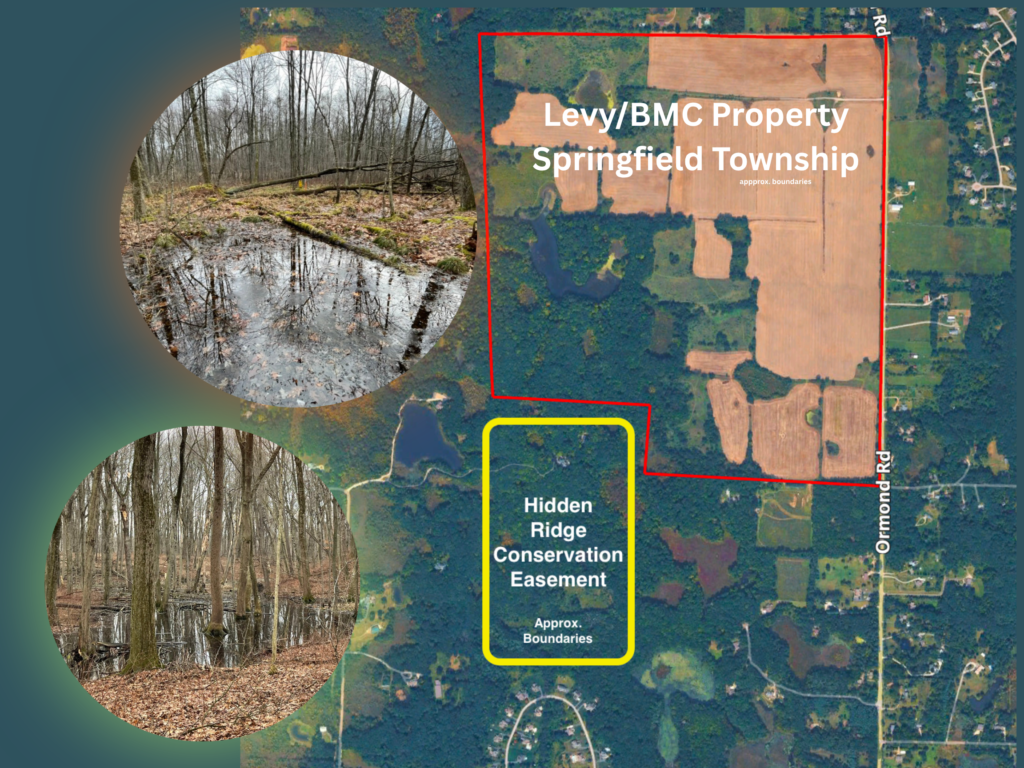
Last week, I had the opportunity to tour the Hidden Ridge conservation easement in Springfield Township with Emily Duthinh of Blue Heron Headwaters Conservancy. What I saw was years of dedicated stewardship including removing invasive species, restoring native habitat, and carefully protecting this land.
The Conservancy and the residents of the Hidden Ridge community have done exceptional work to preserve and restore this area.
This 68 acre conservation easement lies directly south of the property proposed by Levy for a sand and gravel mine.
The Michigan Department of Environment, Great Lakes, and Energy (EGLE) has an interactive tool available to the public called ‘Wetlands Map Viewer‘. When you pull up the wetlands identified in this easement, it will look like this:

Users can click on each wetland in the map to view detailed information. The example shown here (marked by the red diamond) highlights one wetland within the Hidden Ridge area. It lies within the Huron watershed, has a history of Black Oak Barren landcover, and contains hydric soils, along with additional details that become clear as you explore further.
But what does all of this actually mean? Below, I’ve broken down some of the terminology to help make the language of wetlands easier to understand:
| Term | What it Means (Simple Explanation) |
|---|---|
| HUC8: Huron | A large watershed region that drains into the Huron River. This shows the site is part of a much bigger water system. |
| HUC10: Woodruff Creek–Huron River | A smaller watershed within the Huron system, showing more localized water flow connections. |
| HUC12: Pontiac Lake–Huron River | An even more detailed watershed area, showing how closely connected this site is to nearby lakes and streams. |
| Mitigation Watershed: 15 Huron | Confirms the site is managed within the Huron watershed for wetland impacts and replacement. |
| CARL: Hidden Ridge | Identifies the area as part of a recognized conservation and natural lands system. |
| Eco-Region: VI.1.3 | A scientific classification showing this area shares similar soils, climate, and ecosystems with a specific regional zone. |
| Historic Landcover: Black Oak Barren | Indicates the land once supported a rare Michigan ecosystem tied to sandy soils and groundwater conditions. |
| Delineation Region: Midwest | Wetlands here are evaluated using Midwest-specific standards that account for seasonal water and soil conditions. |
| Coordinates (Lat/Long) | Exact geographic location used to map and track environmental data. |
| TRS (Township-Range-Section) | A land survey system used to precisely describe location on a grid. |
| Depressions (moraines, outwash, till plains) | Natural low areas in the landscape where water collects and stays, often forming wetlands. (MSU – Outwash Plains) |
| Runoff: Very Low | Water doesn’t flow away quickly, so it tends to stay in place. |
| Groundwater-Fed System *** | ***The wetland is sustained by water coming from underground, not just rainfall. (FLOW – Groundwater in Michigan) |
| Water Table at or Near Surface | Groundwater sits right below or even at the ground surface, keeping soils wet. |
| Very Poorly Drained | Water does not move out of the soil easily, so the ground stays saturated most of the year. |
| Hydric Soils | Soils that are wet enough for long periods to support wetland conditions. |
| Hydric Rating: Yes | Confirms the soil meets federal criteria for wetlands. |
| Histosols | A scientific soil type made mostly of organic material like peat and muck—classic wetland soils. (Histosols by Plant and Soil Sciences) |
| Houghton Muck (Peat/Muck Soils) | Dark, organic soils formed from partially decomposed plant material in long-term wet conditions. (Houghton Much by National Cooperative Soil Survey) |
| Lowland Hardwood Wetland (Historic) | A wetland forest with trees that grow in saturated soils, showing long-standing wetland conditions. |
This moves from the big picture (regional water systems and conservation context) down to what’s happening in the ground (soils and water). Together, it shows this area is part of a connected watershed and contains the kinds of soils and conditions that naturally support wetlands.
All of this information helps paint a clearer picture of the land, not just what we see at the surface, but what exists underneath and how it all connects. If you’re interested in learning more about this area and the work being done to protect it, I encourage you to visit the Blue Heron Headwaters Conservancy (BHHC) website. They provide valuable information about their work in conservation and the importance of preserving these kinds of natural systems.
Blue Heron Headwaters Conservancy
A big thank you to Emily Duthinh for taking me on a special tour of one of Springfield Township’s true hidden gems.