Same Data, Different Picture
Same Data, Different Picture:
How the Resource Protection Overlay District Got Lost in Plain Sight
One of the most important environmental designations on this site is the Resource Protection Overlay District. It identifies areas where development and disturbance are restricted due to sensitive natural features (such as wetlands, lakes, etc.). In theory, this designation should be clear, consistent, and easy to identify. In practice, it wasn’t.
***Before reviewing the maps below, it’s important to explain why part of this discussion does not appear in the official meeting minutes.
During the October 16, 2025 Fact-Finding Committee traffic meeting, there was a live discussion about whether a potential northern access route to Davisburg Road would cross the Resource Protection Overlay District. That exchange does not appear in the finalized minutes. While these meetings are recorded by the township, the recordings are deleted once the minutes are completed, leaving the written summary as the only public record. Fact-Finding Committee members are not able to review minutes prior to release, and there is no formal process to verify that the written record fully reflects the discussion that occurred. This was one of several exchanges from that meeting that did not appear in the finalized minutes.
During the October 16, 2025 FFC Traffic Meeting with Giffels Webster, the Road Commission of Oakland County, Fishbeck Engineering, and Reuben Maxbauer (Levy/BMC Representative), Township Supervisor Ric Davis raised the idea of a potential secondary access road. The concept involved acquiring private land on the northwest end of the property to directly access Davisburg Road, bypassing Ormond Road.
I immediately objected.
Based on my understanding at the time, that area was protected. I stated that such an access route would not be possible because it would cross the Resource Protection Overlay District.
Giffels Webster responded that the area was not part of the overlay district.
Confused, I pressed again, stating that the area was clearly shown as protected.
Giffels Webster reiterated that it was not, then pointed to a different area on the map — the lower southwest portion of the site — and said, “This is the Resource Protection Overlay District.”
I turned to Reuben Maxbauer of Levy and asked whether that was correct.
He shrugged, raised his hands, and said nothing.
I let the discussion move on, but I was unsettled.
After the meeting, I reviewed the project materials again.
The maps repeatedly shown to the public (including the applicant’s presentation renderings) were dominated by large green areas. Visually, those green areas strongly suggested protection. They looked expansive, continuous, and comprehensive.
But when I searched the documents posted on the Springfield Township website, I found a different rendering — one I do not recall ever seeing presented publicly. This version showed a much smaller and more specific Resource Protection Overlay District.
That’s when it became clear.
I was wrong — and that’s the point.
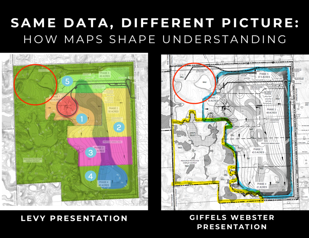
The northwest area I believed to be protected is not part of the Resource Protection Overlay District.
My assumption wasn’t based on carelessness, it was based on visual framing.
The repeated use of green shading on the map from ‘Levy Presentation’ without clear differentiation between protected land, buffers, setbacks, and unregulated open space created a powerful impression. Even someone trained to look for bias absorbed that message.
This is how unintentional bias works.
Why this matters: No one lied. No data was fabricated.
But visual presentation shaped understanding, not just for the public, but for professionals in the room.
Maps are not neutral. Choices about color, scale, boundaries, and emphasis influence what feels protected, what feels constrained, and what feels possible. That influence doesn’t require intent, only repetition.
The lesson: Transparency is not just about making documents available. It’s about ensuring critical distinctions are visible, clear, and consistently presented, especially when they affect environmental systems and infrastructure decisions.
This is why expert review matters -> not to advocate for or against a project, but to identify where framing and simplification may unintentionally mislead. When I raised this issue with independent experts Brian O’Mara and Mike Wilczynski, they immediately understood the concern and described the specific details they routinely evaluate when reviewing visual maps and representations. Despite their qualifications and experience as mining experts engaged by the Township, Brian O’Mara and Mike Wilczynski were not invited to participate in this meeting and have been deliberately excluded from discussions where their expertise would have been directly relevant.